Carol Skinger

  • Home
  • About
    • Carol
    • Policies
    • Pay Online
  • Art
    • Snow Shadows
    • Stain and Flow Abstract Ink
  • Prints
    • ‘Schenley Park Map’ Print Lge $120 Small $50
    • ‘Goats Going Home’ Print $75
    • ‘Snow Shadows’ $55 Print 12″ x 12″
  • News/Blog
  • Contact

‘Schenley Park Map’ Print Lge $120 Small $50

ILLUSTRATED MAP OF SCHENELEY PARK. SHORT HISTORY ON THE SIDE. COLOR IS GREEN WITH RED BORDER
Illustrated Map of Schenley Park in Pittsburgh, PA
Large print $120. Dimension is 30″ square
Small print $50.  Dimension is 19″ square
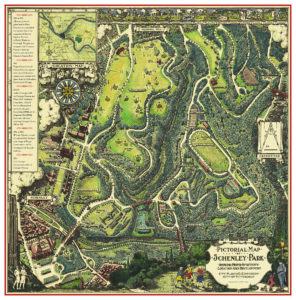
A charming vintage style map showing a bird’s eye view of Schenley Park in Pittsburgh. The Pittsburgh Golf Club and Schenley Park Golf Course are shown along with the roads, forests and trails of the park. Shades of green prevail making the topography of Panther Hollow and Junction Hollow clear. Once Frederick Law Olmsted designed Central Park in NYC, every city wanted to have a grand park and Schenley Park was Pittsburgh’s response. In the 1980s doing park research, found this beautiful illustrated “pictorial” map from the 1930’s, which was a black & white line drawing, possible drawn by Ezra Stiles. I added color and historical information.  3D drawings of buildings are shown including Carnegie Library Main Branch, Carnegie Music Hall and Carnegie Museum as it was in the 1930s. Also seen: Phipps Botanical Conservatory, the Cathedral of Learning at University of Pittsburgh, and early buildings on the campus of Carnegie Mellon University (CMU). Panther Lake is a brilliant turquoise blue to stand out from the greens. Along the top of the map are delightful vignette drawings of activities you can do in the park. The map includes some unbuilt projects such as an amphitheater and an elaborate pool which is where the skating rink is. Four bridges are drawn: the Greenfield Bridge, Schenley Bridge, Panther Hollow Bridge and the Charles Anderson Memorial Bridge. I changed the street names to the current names. Copyright with my changes and additions by Carol Skinger
More information about my map
Share:

Stress reduction with pictures of greenery!

March 28, 2016

Carol Skinger's SchenleyParkMap 1

Most folks would agree a walk on a path in the woods or in a park is rejuvenating. After a few minutes you leave your cares behind. Data suggests that a short duration of viewing green pictures may help people recover from stress. Read a New York Times article here on this subject by author Gretchen Reynolds.

If it were that simple to lower stress by mentally taking a walk through this pictorial map of Schenley Park wouldn’t that be a great addition to your home or office, or as a gift to a family with a new baby?

But who needs an excuse to fall in love with the Schenley Park Pictorial Map? Penned in the late 1930’s a time in history we cannot call stress free, perhaps  the illustrator found it calming to draw the park. I found a print of the black and white ink drawing in the 1980’s while researching the park. I was so enchanted by it I added color and a brief park history.

Prints in two sizes are always available from me and can be ordered here.

If you love pictorial maps here is a link for more reading.

Share:

Filed Under: Blog Tagged With: be in nature to reduce stress, green pictures reduce stress, Healing art, pictorial maps, Pittsburgh, Pittsburgh is green, present for a new baby, Schenley Park, Schenley Park Map

Licensing my work for use: Schenley Park Map

January 7, 2016

Carol Skinger's Schenley Park Map - OptSchenly Pk map in Mary Schenley article Fall 2015 - OPT

I was excited when the quarterly magazine Western Pennsylvania History Magazine contacted me about using my Schenley Park Map (on the left) to illustrate a stunning and thorough 14 page article (125 citations!) about Mary Schenley titled “What’s in a Namesake” by Jake Oresick. It was published in Fall of 2015. Their publications are beautifully printed and designed and I could not be more thrilled to be part of it. This is the spread page where my map appears.

You can order a map from me and it is here on my site in two sizes 18″ square and 30″ square. It is a wonderful help in keeping my art supplies stocked and dealing with various dollar and cents issues we all have!

Listen to an NPR story about Mary Schenley written and produced by Margaret J. Krauss where she and author Jake Oresick talk about Mary Schenley.

I am always happy to discuss license agreements to use my work, and in the case of Schenley Park, the park has been a passion of mine since moving here from Boston years ago. Obviously this is a Depression Era drawing and I am not old enough to have drawn it myself. As an artist, when I found the black and white drawing in a file, it broke my heart to think Pittsburghers had no way to enjoy this map.

So I added color, information, history and a red border to make it more compatible with the Frick Park Map which people love to frame together as a set. Though at this point in time (2024) the Frick Pittsburgh Museum store does not carry Frick map anymore. I never set out to be a map seller but no one else I approached would take it over, so I decided to do it myself. It brings such pleasure to so many people who love that park and it is a beautiful piece to get lost in while studying it.

The BIGGEST audience for my print is children and men! So, Pittsburgh women or men who do not know what to get for your husbands, buy a print! Or folks who have to come up with a memorable baby present but don’t want to contribute to instant landfill, buy a print! Or alumni of Pitt, CMU and Carlow who are not fond of pennants or logos, this is your go to gift!

If you would like to discuss licensing any of my work shoot me a message through my site.

Share:

Filed Under: Blog Tagged With: Carol Skinger, City Beautiful, Depression Era Drawing, Licence this art, Mary Schenley, Oakland History, Pittsburgh, Pittsburgh History, Romantic Park Design, Schenley Park, Schenley Park Map

Schenley Park Map

June 27, 2015

Map2013

18″ square map  $50

30″ square map $120.

Read more about the map

Contact me to order

Share:

Filed Under: Blog Tagged With: Carnegie Institute of Technology, Cathedral of Learning, Junction Hollow, Mary Schenley, Panther Hollow, Panther Hollow Bridge, Panther Hollow Lake, Phipps Conservatory, Pittsburgh Vintage Grand Prix, Schenley Golf Course, Schenley Park, Schenley Park Map, Westinghouse Memorial

Schenley Park Illustrated Map

March 5, 2013

Schenley Park Map

I am an artist myself and lover of nature and hiking. I found no decent map of Schenley Park  when we moved here from Boston in the 80’s, so  decided I would illustrate it myself having discovered acres of wonderful hiking trails many of them former bridal trails, just by being curious. My research in several historic archives lead me to a copy of a Depression era line drawing with no color , likely made for the 1939 anniversary. This is it! No one can beat the illustrative style of this historic drawing and it should be available. I LOVED the orientation of the drawing with East at the top. Unusual but so right for this park.  All it needed was a brief history in the blank text box in the upper left, updated street names, and a few notes explaining some few elements that were illustrated but not built. Most important of all it needed an artist’s hand to add color, and I am an artist, so DONE! I created the color using color pencils.  Later comparing it with the Frick Park illustrated map I added the red border  which is so effective on the Frick Park map.

Perhaps you live near the park, or attend college in Oakland or run in the Pittsburgh Koman Race for the Cure.  Have you ever watched  the Pittsburgh  Vintage Grand Prix in the summer? Did you read or see Perks of being a Wallflower and want to visit Schenley Park? You should!

This illustrated map is a great piece of artwork originally inked in the 1930’s, with many updates by me including color, that literally draws you (so to speak) into the park. Want to know more of the history of the park and it’s creation? Click here. And more info here.

I have now made the illustrated map available to see and order in the first public place inside the park itself: Schenley Park Cafe and Visitors Center . They have a large framed map right next to the counter where you order, and they keep a small inventory of the maps in 2 sizes. The Schenley Park Map of either size can always be ordered on my website here.

Schenley Park  Cafe and Visitors Center ExteriorSchenley Park Cafe and Visitors Center

Schenley Park Cafe & Visitor Center           Inside an Urban EcoSteward studies the map!

It is a great place to order lunch and take a walk onto the trails right out back of this charming building designed by Rutan and Russell . You also can plan catered events there!

If you order through my  website it takes 3 or 4 days and there are options for shipping the print in a tube. It is available both as 30″ square as displayed there, or a smaller size 18″ square to match the height of the Frick Park Map. The Frick Map  which is available at the shop at Frick Art and Historical Center in Point Breeze. If you want to see the Frick Park Map and how it relates to the Schenley Park Map I wrote about it here . You can always simply call me to order it. 412-401-8812.

What is shown in the illustrated Schenley Park Map, other than the park land, trails and park amenities? Carnegie Institute of Technology  (now Carnegie Mellon University), The Cathedral of Learning at the University of Pittsburgh,  Carnegie Library (Main Branch) Pittsburgh, Forbes Field, Phipps Conservatory, Greenfield Bridge, Panther Hollow Bridge, Charles Anderson Bridge.

Share:

Filed Under: Blog Tagged With: antique map of Pittsburgh, Carnegie Library, Carnegie Mellon University, Cathedral of Learning, Depression era illustration, Forbes Field, Great parks, Panther Hollow Bridge, Phipps Conservatory, Romantic Parks, Schenley Park, Schenley Park Map, University of Pittsburgh

Contact Carol

  • If you are inquiring about a print or artwork, please specify which one.

Copyright ©

Carol Skinger. All Rights Reserved.